About
Objectives & Themes

Objectives
- Establish a standard for managing and governing data in spatial and linear referencing systems at transportation agencies, including but not limited to routes, intersections, interchanges, roundabouts, road segments, roadway characteristics, infrastructure assets, model inventory of roadway elements (MIRE), HPMS data items and ARNOLD road network.
- Develop guidance for States for engineering spatial transportation data and preparing it for sharing and provisioning at the enterprise level, across various business functions and stakeholders at the DOT and their Federal, State and Local partners.
- Conduct a series of webinars, workshops, peer exchange meetings and provide consulting services to the States participating in the pooled fund to develop national standards in data modeling and management; enhance existing enterprise GIS systems at these agencies.
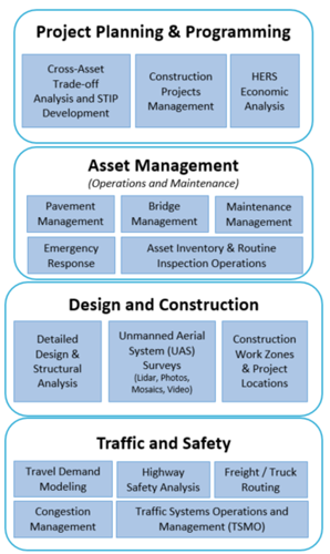
- Update the AEGIST Guidebook that was prepared in Phase 1, by documenting best practices, patterns and similarities across agencies in managing spatial data using enterprise data systems, including but not limited to Asset Management Systems, Traffic and Safety Systems, Project Planning and Programming Systems, Design and Construction Systems, and GIS and Linear Referencing Systems (LRS).
- Collaborate with States to enhance and develop spatial data management systems, processes, platforms to establish a structured and systematic approach for management of spatial data. This would involve establishing spatial data governance systems, business rules, applications, tools and platforms for:
- Spatial Data Modeling
- Spatial Data Integration and Engineering
- Spatial Data Analytics
Themes
Spatial Data Modeling, integration, Quality, Governance and Standards Compliance
- Roads Data Model: Linear Referencing Routes, Centerlines per HPMS, ARNOLD, USRS, NG911
- Intersection Data Model (MIRE and IFC Roads Compliant)
- Routable Network Data Model for Detours, Emergency Vehicle and Trucks Routing
- Roadway Data Model for Highway Safely Analysis
- Bridge and other Structures Data Model for Asset Resiliency Analysis
Data Governance for Building Information Modeling (BIM)
- Manage Data as an Asset using a Data Portfolio: Tool for Data Governance Council
- Use Data Engineering Platform for Integrating and Engineering Data across Enterprise Systems
Spatial Data Readiness and Use in Business Operations for Diagnostic and Predictive Analytics and Decision Support
- Traffic Systems Management & Operations
- Freight Network Modeling
- Strategic Highway Network (STRAHNET)
- Highway Economic Requirements Analysis (HERS)
- HPMS, ARNOLD, NBI, NBE-BME Reporting
- Highway Safely Analysis
- Travel Demand Modeling
- Asset Performance, Resiliency Analysis
- Project Selection, Planning and Prioritization
- As-builts, Asset Inventory and Condition Management
Resources
- AEGIST Guidebook under Advanced Technical Review – Available upon request to State DOTs
- AEGIST FHWA Pooled Fund Site
How do I get involved?
Contact: Abhishek Bhargava, WSP
abhishek.bhargava@wsp.com
How does my agency benefit by getting involved?
- Receive 750 hours of services to plan and support technical priorities of Pooled Fund Study agencies.
- Receive guidance on agency-specific issues and challenges.
- Share in peer states and agency best practices information.
- Advance data modeling, integration, engineering, analysis tools and standards.