About
Spatial Data Governance
Deploying spatial data governance practices starts with establishing information requirements based on business use cases.
Data modeling is then done based on these requirements and involves establishing the data structures, data quality and modeling business rules.
This is followed by data preservation in on-premise or cloud-based data systems of record (SoR) and/or data systems of engagement (e.g. data hubs, data lakes, data warehouses) for sharing, integration and interoperability of data.
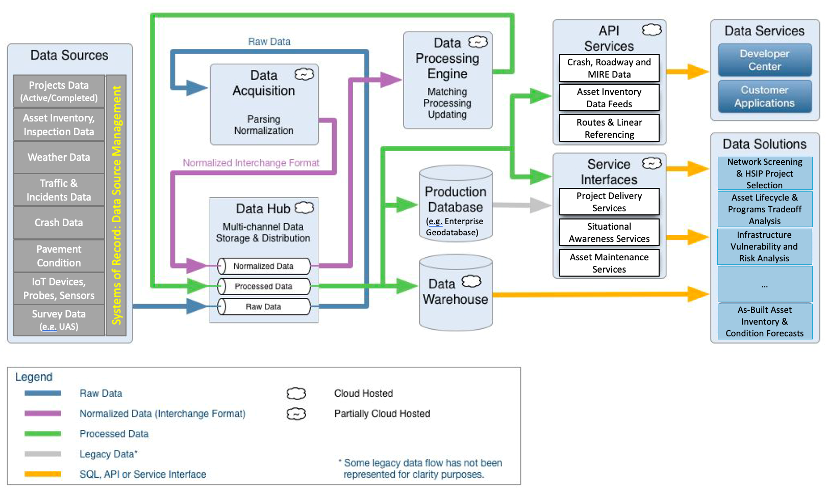
Data engineering platforms are deployed to acquire, process and integrate data from multiple authoritative sources and make data available to data analytics platforms (e.g. spatial data portals, dashboards).
To integrate and engineer data for use on analytics platforms, authoritative data sources must be governed, and data models of these data sources must be aligned.
Modeling data in these authoritative systems involves maintaining data quality, data relationships, topology, connectivity, temporality, metadata and data quality.
AEGIST focuses on all these aspects of spatial data governance, with specific emphasis on enhancement and implementation of enterprise spatial data modeling, integration, engineering and analytics platforms at transportation agencies.
Spatial Data Modeling
Spatial data modeling involves creating a GIS-based linear referencing data model comprising of routes, centerlines and linear referencing events.
It also involves creating data models for other spatial transportation data including but not limited to the following:
- Traffic and Safety Data Models for capturing Incidents, Crashes, MIRE FDEs, Intersection Elements, Traffic, Weather and Streaming Traffic Systems Management and Operations data from IoT devices, probes, sensors, and traffic systems.
- Routable Network Data Model with Topology, Connectivity, Turn Penalties and Restrictions for Emergency Response, Detours Planning, Routing, Travel Demand Modeling, Forecasting Traffic Analysis, CV/AV and UAV Systems.
- Asset Inventory, Performance Risk and Resiliency Analysis Data Models for Roads and Assets Inventory Operations, Asset Life Cycle (LCP), Transportation Asset Management Plan Development (TAMP), Asset Performance Analysis, and Highway Performance Monitoring (HPMS) & Economic Analysis (HERS).
- Project Information Model (PIM) for Project Funding and Financial data, Project Locations (Assets, Routes, Segments, Right-of-way Assets), and Environmental Impact and FMIS data.
- Survey and Design Data Models (2D-9D) built using existing asset data models from GIS and LRS data systems. Development and exchange of digital elevation, point cloud, mosaic and imagery data between design, GIS, LRS and asset systems.
- Asset Information Models (AIM) for Routes, Bridges, Pavement Sections, HPMS Sections, Tunnels, Retaining Walls, Noise Barriers, Signs, Signals, Guardrails, Interchanges, Roundabouts, Intersections, Guardrails, Medians, Shoulders, Markings, Crosswalks, Sidewalks, Environmental Assets, Utilities, Parcels, Fiber, etc.
Spatial Data Integration and Engineering
Spatial data integration and engineering involves acquiring and integrating data stored in different authoritative data systems and data models. The data imported and integrated from the authoritative systems is processed in data hubs or using data engineering tools and released to production business intelligence databases, data warehouse, application programming interfaces (APIs) and data services for use by business users and systems in analysis and decision support systems.

Spatial Data Analytics
Spatial data analytics involves using the engineered and processed datasets on the engineering platforms for descriptive, diagnostic, predictive and prescriptive analytics in a variety of business processes and systems, including:
- Traffic Systems Management and Operations
- Freight Network Modeling
- Strategic Highway Network (STRAHNET)
- Highway Economic Requirements Analysis (HERS)
- HPMS, ARNOLD, NBI, NBE-BME Reporting
- Highway Safety Analysis
- Travel Demand Modeling
- Asset Performance, Resiliency Analysis
- Project Selection, Planning and Prioritization
- As-builts, Asset Inventory and Condition Management
Resources
- AEGIST Guidebook under Advanced Technical Review – Available upon request to State DOTs
- AEGIST FHWA Pooled Fund Site
How do I get involved?
Contact: Abhishek Bhargava, WSP
abhishek.bhargava@wsp.com
How does my agency benefit by getting involved?
- Receive 750 hours of services to plan and support technical priorities of Pooled Fund Study agencies.
- Receive guidance on agency-specific issues and challenges.
- Share in peer states and agency best practices information.
- Advance data modeling, integration, engineering, analysis tools and standards.


